Mike Turnbull Yarrol May 2026
|

|
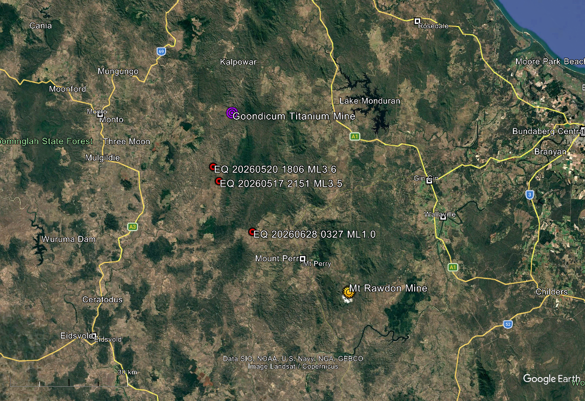
On 2026-05-17 at 21:51 UTC an ML 3.5 earthquake (Event 1) occurred in the Yarrol Block, about 35 km southeast of Monto in Central Queensland. This was followed by an ML 3.6 in the same place on 2026-05-20 at 18:06 (Event 2).(See Figure 1). The shaking from this earthquake was felt strongly (MM IV) in the southern suburbs of Ipswich and very strongly (MM VI) in Noosa.
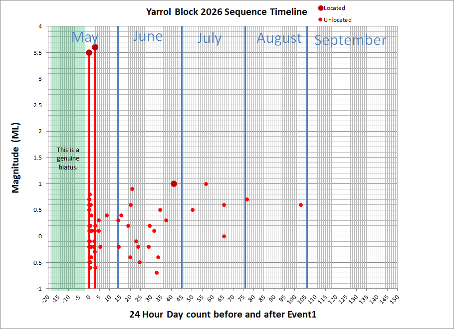
(Refer to Figure 2) Event 1 was followed over four days by 32 small aftershock events from ML 0.6 to ML 0.8. Event 2 was followed over 34 days by 20 aftershocks ranging from ML 0.6 to ML 1.0. All but one of these aftershocks were only recorded on the Eidsvold (EIDS) station operated by Geoscience Australia and were not located. Inspection of the EIDS records indicates that there were no similar precursor events prior to Event 1. A noticeable feature of the sequence is the distinct separation between the magnitudes of Events 1 and 2, and the assumed aftershocks. Their associations with Events 1 and 2 were either implied by their coincidental S-P times, or by location; however, it may be that they represent the long-term background seismicity of the Yarrol Block and have not been triggered by either Event 1 or 2, but (a) previous much larger event(s). The sequence is ongoing, but waning, with there currently being a couple of ML ~0.6 to 0.7 events per month.
It has been suggested that Events 1 and 2 should be considered aftershocks of the 2015-02-15 ML 5.0; and this could certainly be true. Under normal circumstances it would not be expected that earthquakes of the order of ML 3.5 could generate an extended aftershock sequence, and if these small, assumed aftershock events continue for an extended period it may be that they have not been generated by these recent ML3.5 and 3.6 events. However, this suggested more distant association could go back to the 1935-04-12 ML 6.1; or even to the 1918 -06-07 ML 6.0 to 6.3. Using that reasoning, we could further go back hundreds, thousands, hundreds of thousands etcetera of years to the great earthquakes of unknown event times that shattered the Yarrol Block to the complex of faults it now displays. At some stage we need to draw a line in the sand; or, in this case, in the admittedly very long event timelines, and determine that one aftershock sequence has been terminated by the occurrence of a subsequent generational event; and that is what I have chosen to do.
The Yarrol Block (See Figure 1) is located between Mt Perry and Monto and is the head waters of the Burnett River. It is heavily mineralized and contains the Monto (Goondicum) open cut Titanium Mine (see the aspherical truncated pluton feature in the top middle of Figure 1). In the southeast the historical Mt Perry Mine (a large source of gold, silver, copper, and other polymetallic ores), and the operational Mt Rawdon open cut gold/silver mine.
The whole of the Yarrol Block consists of a complex of earthquake faults. It presents a continuous seismically active zone and is notable for having generated the 2015-02-15 ML 5.0, and the April 2035 ML 6.1 earthquakes. It has been recently speculated that the “Great Queensland Earthquake” (Somewhere between ML 6.1 to 6.3) in June 1918 occurred in this area, not offshore from Gladstone as previously thought. The fractured condition of the geology suggests seismic activity of very large earthquakes over geological time.
A full catalogue of earthquakes that I have located since 2004 is available online.